In an increasingly changing environment and warming climate which threatens the very existence of mankind, good data and information on exactly what is happening has never been more important.

“For us climate change is not an event in the future. It's an event that we're dealing with now…our entire survival is at stake” - Anote Tong, former President of Kiribati
The pursuit of meaningful climate data
In an increasingly changing environment and warming climate which threatens the very existence of mankind, good data and information on exactly what is happening has never been more important. If we do not have the right information, in an accessible and easy to interpret manner, then it is very hard to develop the policies and actions required to tackle climate change.
Good data is therefore essential for effective decision-making and new technologies are producing unprecedented volumes of various types of data, creating what has been termed as a data revolution.
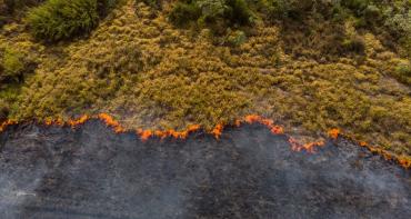
As discussed in the previous blog, satellite EO can provide good data as it is scalable, allowing wide coverage which is consistent and comparable, and which can be frequently collected and even combined with other applications. For example, EO can provide accurate, real time data on land cover, topology, ground water and soil moisture and atmospheric changes. When combined with other systems, the type of data available and applications are endless. Such technological developments have been very beneficial for climate action, enabling decision-makers around the world to undertake evidence based actions to the save the planet.
However, not everyone is benefiting from this data revolution.
Although developing countries and small states are already bearing the brunt of the impacts of climate change and are having to make critical decisions on the best way to save their people; these same countries are operating in reduced data environments, making monitoring and projecting change very challenging. For this reason, there is a risk that professionals in these countries may make decisions without enough supporting evidence and information.
When it comes to satellite EO data, even where it is available public bodies in small and vulnerable states have limited human, technological and financial resources to fully exploit its benefits for enhanced climate action.
The recipe for success: one-part data and one-part capacity building
As explained in Part 1 of this blog, Satellite Earth Observation (EO) technologies are rapidly becoming an important tool in the fight against climate change due to their ability to monitor environmental and climatic changes over time.
While there is a general agreement of the growing benefits of EO data, the challenge remains that users must undertake a series of complex steps to convert the raw data into a form that can be easily analysed and effectively utilised.
For this the user requires the necessary technical knowledge, software and infrastructure this is especially challenging for developing countries. Therefore, an opportunity to maximise utilisation of this data by non-specialist users presents itself. One of the ways of doing this is through analysis ready data (ARD).
This is pre-processed satellite data that has been organised in a format ready for easy analysis without the need for additional processing by the user.
As part of a joint partnership, the Commonwealth Secretariat together with an international consortium is delivering an ARD solution combined with capacity building to three Pacific Island countries through the CommonSensing Project.
The objective of the project is to build climate resilience and enhance decision-making in Fiji, Solomon Islands and Vanuatu by delivering satellite based tools, information and capacity building for improved climate action. The project addresses four key thematic areas, namely disaster risk reduction, climate finance, food security and climate services.
CommonSensing leverages EO data to provide stakeholders with access to vital satellite based information services regarding disaster and climate risks to inform planning, food security needs and to strengthen access to climate finance.
The CommonSensing platform takes data from remote sensing, local and global data sets and provides a free data service that is already processed in a format for immediate use.
In addition to providing a data platform, the CommonSensing project will also build capacity and strengthen technical skills in the use of the platform and related satellite information services. This will be enhanced by placement of technical geospatial specialists within government ministries to support government officials and decision makers.
Through the Commonwealth Climate Finance Access Hub, the Commonwealth is placing Three Climate Finance Advisers in Fiji, Solomon Islands and Vanuatu with the aim of supporting access to climate finance.
Leaving no one behind
Satellite EO technologies have grown in leaps and bounds, providing decision makers with critical information and evidence to help tackle the global climate challenge.
Nevertheless, in order to enhance its utilisation for enhanced climate action, it is imperative the most climate vulnerable nations in the world are not left behind and that they too can maximise the benefits of the growing investment and advancements being made in this space.
Read part one: Leading the fight from above: Space technologies for enhanced climate action