“We are in trouble. We are in deep trouble with climate change. Climate change is running faster than we are and we must catch up sooner rather than later, before it is too late”. United Nations Secretary-General, António Guterres at UNFCCC, COP 24

“We are in trouble. We are in deep trouble with climate change. Climate change is running faster than we are and we must catch up sooner rather than later, before it is too late”. United Nations Secretary-General, António Guterres at UNFCCC, COP 24
What we are up against
The fact that climate change is one of the greatest threats facing humanity today is irrefutable.
Unfortunately, the stark reality is that climate change can potentially reverse hard-earned development gains because it is developing countries and small states that are particularly vulnerable and disproportionately impacted.
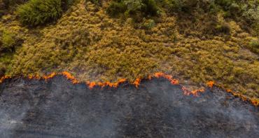
Developing countries, especially Small Island Developing States (SIDS), are on the frontline and bearing the brunt of adverse impacts such as sea level rise, change in weather patterns, increased frequency and intensity of natural disasters, biodiversity loss, increased food insecurity and vector borne diseases, just to mention a few. Therefore, for these countries adaptation is critical because they are already experiencing the devastating impacts. and so they must make decisions on the best way for them to adapt.
Accelerating action to address climate change is therefore not a choice but an urgent necessity for the survival of mankind. It is in this vein that the United Nations Secretary-General UN spearheaded a Climate Action Summit in September 2019 to urge countries raise their level of ambition in tackling climate change.
As detailed in the 2018 IPPCC Special Report on 1.5 Degrees, limiting global warming to 1.5 degrees will require rapid and far reaching transitions in all sectors and can be enabled by, amongst other things, accelerating technological innovation.
How satellite technology is aiding in the fight
Technology is widely recognised as an important element in addressing climate change and is a core element in the United Nations Framework Convention on Climate Change (UNFCCC) process with specific provisions under the convention.
The Paris Agreement speaks to this through the Technology Framework, which will guide the implementation of the Technology Mechanism that was established at the 21st Conference of Parties (COP 21) with the aim of accelerating development and transfer of climate technologies.
In recent years, satellite technologies that support Earth observation (EO) and have evolved rapidly, providing solutions to help tackle climate change and support disaster risk management (DRM) - especially when combined with applications such as Geographic Information System (GIS) that allow for detailed analysis. These technologies can therefore enhance decision-making by providing evidence and data.
Satellite EO can support climate action by providing accurate information on the status of oceans, coasts, rivers, vegetation and soil cover and the atmosphere using tools which can be deployed remotely from space and in-situ.
EO tools can also monitor change over time, providing valuable time series data which is especially important for assessing risk and enhancing understanding of vulnerability.
Therefore, Satellite EO technologies have the potential to play a key role in DRM including disaster risk reduction (DRR).
These tools can be deployed remotely and are not impacted by the disaster itself meaning they can provide detailed updates on the status of various hazards in inaccessible areas during a disaster - for example, monitoring the path of tropical storms, mapping the extent of flooding, forest fires, and monitoring drought. EO can also support disaster preparedness through hazard mapping and analysis of risks, for example the risk of a particular area flooding can be projected to support planning and early warning systems.
With increasing investment in this technology, there is now a growing availability of free and open satellite derived EO data, removing the investment and cost barrier for many developing countries.
EO also has the advantage offering a wide range coverage, from local to global, enabling observation of very remote areas. In addition, EO data offers consistency which allows results to be compared effectively without the common challenge of standardisation of measurements. This is particularly important for monitoring and measuring environmental and climatic changes in different parts of the world.
Leveraging Innovation in the Commonwealth
Recognising the increasing investment and advancement in this area, the Commonwealth has entered into an innovative partnership that brings together different expertise from across the 53 countries to support Commonwealth SIDS to better utilise satellite EO to support enhanced climate action and build resilience.
The Project known as Commonsensing is funded by the UK Space Agency’s International Partnership Programme (IPP) and is being delivered through an international consortium leveraging unique strengths and technical know-how to directly respond to specific needs.
In Part 2 of this blog series I will expound more on the Commonsensing Project and how it is providing assistance to the most vulnerable nations to step-up action and meet their climate goals.
Read part two: Leading the fight from above: Space technologies for enhanced climate action